To create an autonomous water supply on the site, you first need to make your own source. To do this, it is important to find out at what depth the water for the well is. This will greatly facilitate the task, help to calculate your strength, choose the necessary equipment for drilling.
Aquifer Overview
In order not to run into an aquifer of poor quality, it is important to know about the characteristics of a given horizon, since not every one of them is suitable for domestic use, especially for drinking, cooking.
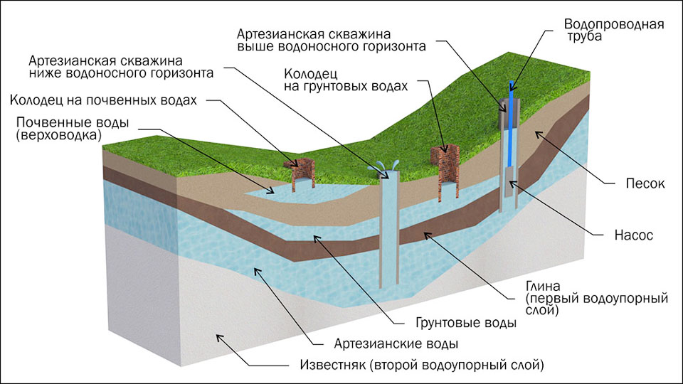
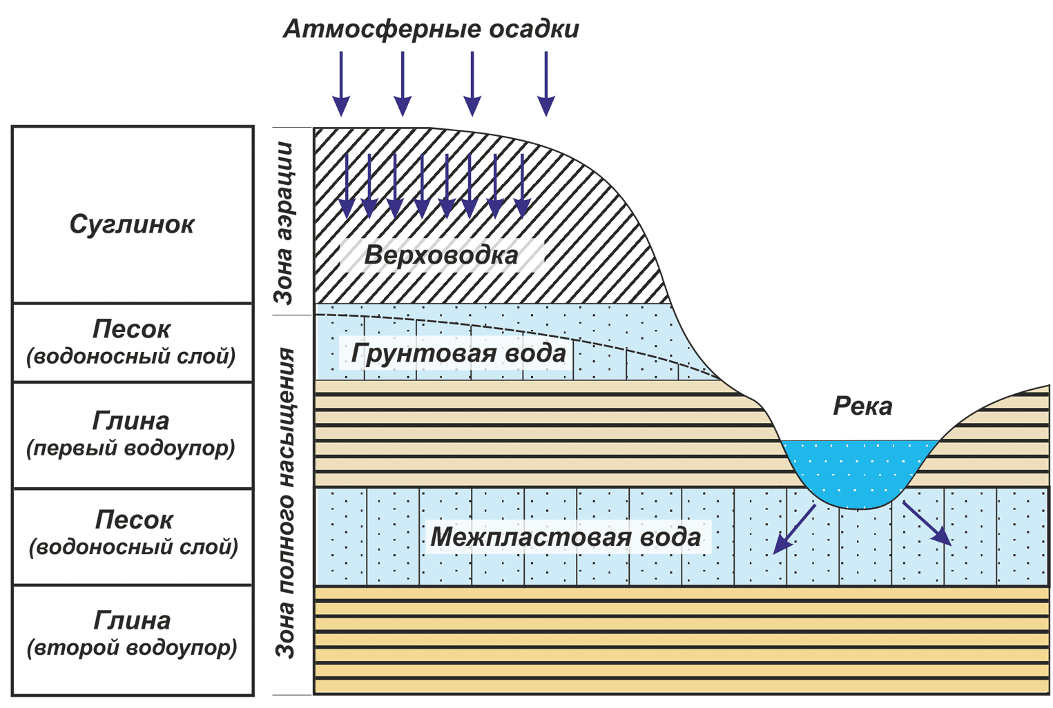
All aquifers are strata underground having a ceiling (top) and a sole (bottom). As a rule, these are layers consisting of clay, stone or limestone. Water is contained in them either under pressure or without it. In the first case, the layer is called pressure, in the second - non-pressure.
All aquifers do not have a flat plane. They tend to bend, form bends, height differences. Therefore, wells of different depths can be located on the same horizon.
To detect the resource underground, it is desirable to use hydrogeological maps of the area. They, as a rule, are in the archives of a particular settlement.
By depth, all aquifers are divided into types:
- High vault. This is the first 2.5-5 meters from ground level. Such strata contain all the water that has been absorbed from the soil during the rains, which have gone into the ground from the drain pits, leaked from industrial enterprises. Such a resource is unsuitable for drinking, as it often has a high level of pollution with toxic poisons, pesticides, nitrates, acids, etc.
- Sand layers. They are located at the level of 8-12 meters and more. It is believed that here the water is purified as much as possible, since it passed many levels of filtration while it got from the surface to this horizon. It is at this depth that more often dig wells or drill wells on the sand.
- Artesian deposits. Go deep into 50-200 meters. Such water is already considered mineral. An artesian well needs a license, since water resources are under state protection here. It is unrealistic to search for an artesian source using folk techniques.
Artesian wells are best drilled into several houses at once, because they have a very high flow rate. For one family, this water will be abundant.
Preliminary exploration of the field
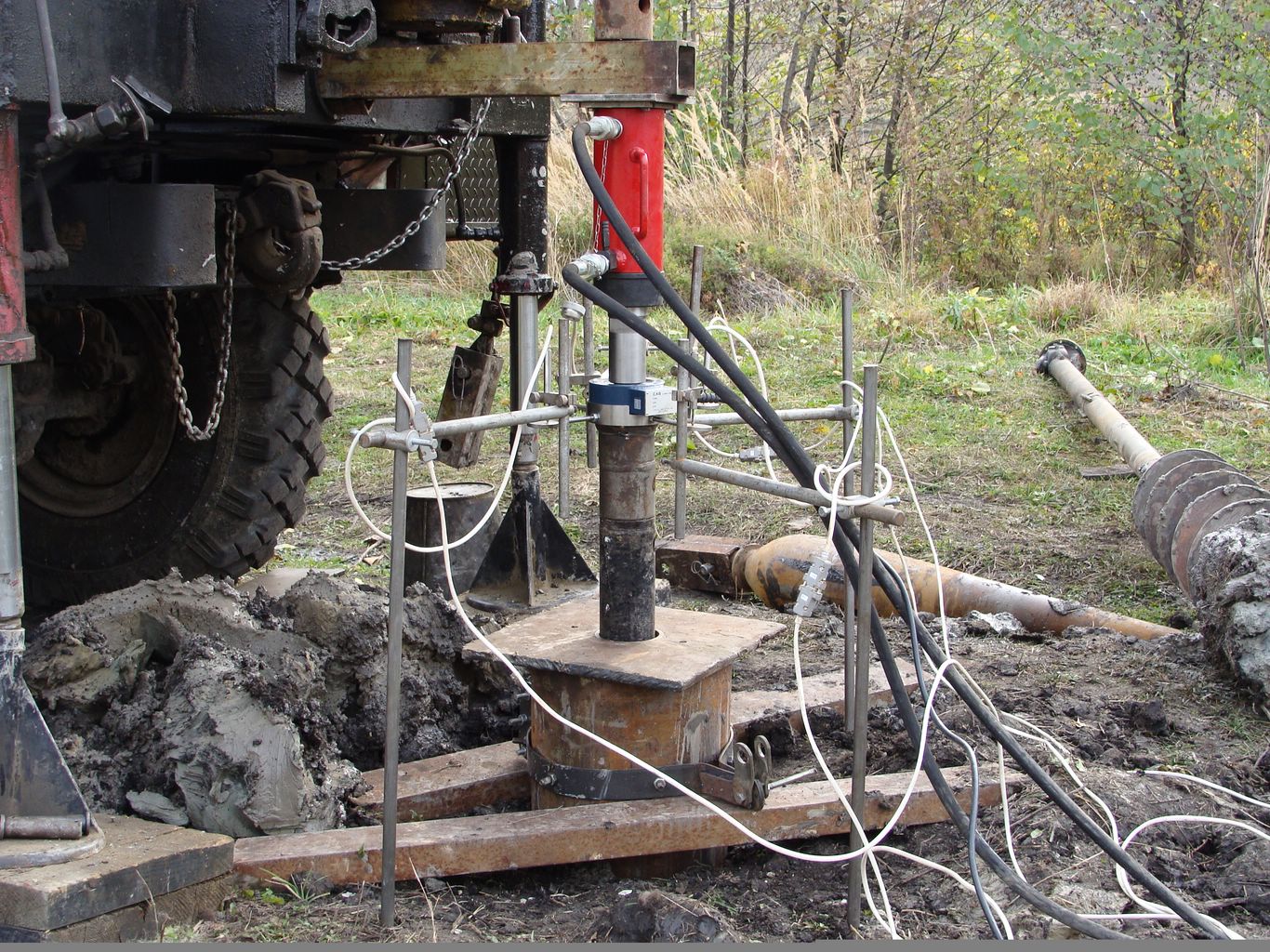
In order for the water search at the well site to be as accurate as possible, it is advisable to conduct hydrogeological and geophysical research, exploratory drilling. When performing such work, the master not only determines the depth of the underground source, but also reveals:
- soil subsidence level;
- categories and complexity of their penetration;
- the nature of the stability of each layer of soil during drilling.
Exploration can be performed in several ways:
- Rotary. The rotation of the drill with flushing the source column is implied.
- Column. It is used for great depths, as drilling equipment can cut rocks.
- Shock-rope. Here, an exploratory well is drilled under the influence of the weight of a projectile lowered from a height.
To conduct exploratory drilling, it is better to invite specialists.
Groundwater search methods at the site
It is quite possible to find a place for a well on the site yourself, if you apply special techniques. One of them is electrical sensing. For this, devices are used - current recorders.
In vertical electric sounding, different soil layers (underground rocks and aquifers) give different electrical resistivity. Water deposits are lower than mineral skeletons.
The disadvantage of this method is the following - there may be an error in determining the depth of the aquifer, if there are deposits of iron ore in the thickness of the earth. They distort the testimony of the registrar. The same thing happens with a close proximity to the place of study of iron fences, railway tracks.
How to find water on your own
To determine where to drill a well under water, the following methods are considered the most common:
- Clay pot operation. It needs to be placed with the bottom down at the proposed drilling site. If an aquifer occurs, clay will gain moisture overnight.
- The use of glassware. You can use ordinary cans of 0.5 liters. Several of these vessels are placed on the site from the evening down the neck. The one that in the morning will contain more condensate indicates the presence of water underground.
- The use of silica gel. It must be wrapped in a dry piece of cloth, laid in an earthenware container and buried in the intended location for drilling. Pre-silicate balls must be weighed. After a night in the soil, the container is dug up and the gel mass is measured. Thus determine the level of its satiety with moisture.
- Aluminum frames. A long-standing method that our grandfathers used to choose a place under the well. To conduct the study, you need to take two pieces of aluminum wire of 40-50 cm. One end of each of them must be bent at a right angle by about 10 cm. Then the wires are inserted into special hollow tubes without a core (preferably from elderberry). Holding such frames in their hands, they walk around the site. It is important to press your elbows to your sides. If the master passes over an aquifer, aluminum frames are crossed. This place must be designated and go along it again, but perpendicular to the original direction. Where both lines converge, it’s worth drilling.
Instead of aluminum wire, you can also use cuts of grape and willow vines. They need to be well dried beforehand.
Omens
You can find the presence of an aquifer in the area using the observation method. There are a number of valid signs of the location of groundwater:
- Morning fog. As a rule, in places of maximum water availability underground, it spreads thickly, swirls and does not go down for a long time. The more fog, the closer the desired layer to the surface of the earth.
- The presence of different plants. If their root system at the proposed drilling site is too weak, then groundwater is close to the surface. If the roots grow deep, have a powerful appearance, the water here is at the level of several tens of meters. In turn, you can find and track certain groups of plants, which are indicators of the presence of water underground. Such are nettle, sorrel, coltsfoot, alder, willow.
- Maturity level of fruit crops. It is believed that if cherries, cherries and pears constantly rot, the desired horizon passes close to the surface of the earth.
- The behavior of animals in the heat can also affect the choice of drilling location. Indicators are dogs and horses. The first always dig a hole in places of high humidity and fit into it. The horses in this place diligently beat the hoof. Seeking moist soil and geese released for a walk in the heat.
- Moshkara also helps to find out about the availability of the desired resource underground. She rummages in the evening where exactly there is a hidden source.
It does not bother to walk around the neighbors and find out from them at what level their wells and wells operate.What previously obtained results of the deepening by the drill, and at what level it is impossible to drill, so as not to exhaust the flow rate of one layer, if several wells are fed from it.